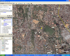
Screen shot of Jos Nigeria
Originally uploaded by Jonathan D. Blundell.
Back in July I reported that Google Earth had updated their satellite images of Jos, Nigeria (where Rob and a group of others from Lakepoint spent two weeks).
I shared the info with Mike Blythe, a missionary there working with the ECWA hospital.
Mike just sent me a link for a killer KMZ file that highlights lots of areas around Jos – including many of the sites that we saw and worked at while we were there.
To view it – be sure you have Google Earth installed and the open the link. It should automatically populate your “My places” with all the sites in Jos.
Big props to Mike! Makes me really want to go back there.
Related ::
Google Earth
the Jos, Nigeria KMZ file
SSL :: Google Earth updates Jos Nigeria
Mike Blythe’s blog
Google Earth :: Jos Nigeria KMZ file
Photos from my 2006 trip to Jos
Photos of the football/soccer stadium mentioned in the KMZ file :: 1 2 3 4 5 6 7 8
CWF photos from Nigeria 2007
CWF :: Christian Wrestling Federation